")
")

- suitable for: children aged 6 or above, partially suited to strollers (younger kids should be carried in a backpack)
- elevation gain: +400 metres overall (not consecutive)
- distance: 13 km overall
- estimated time: 4,30 hours
- route type: loop with asphalt, dirt road, path, grassy tracks
- starting altitude: 250 metres
- maximum altitude: 280 metres
- minimum altitude: 160 metres
- when: all year round in absence of snow
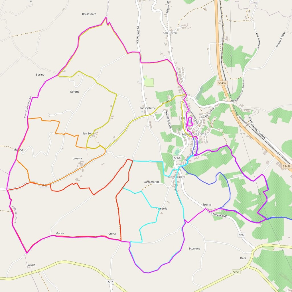
From Piazza Roma, where you can park, take Via Corte and then turn right onto Via XX Settembre at Salumeria Truffa (brown "panoramic point" sign). Go slightly uphill to reach a small square, overlooking two sacred buildings. Continue on Via XX Settembre to the left, towards the tree-lined avenue that offers a first panoramic view, then turn right onto Via Cesare Battisti (brown "panoramic point" sign). After a short climb you reach a tower, its top overlooks the surrounding area and from there it is possible to see the route to follow. Once past the tower you will find a large playground while the road takes a circular turn back to the previous junction.You turn right towards the little church of Santa Croce, keeping it to your left, and walk along an asphalted road that passes through another small panoramic garden.
Turn right to take nearly immediately the road on the left (blue signs for various hamlets, including Cascinetta). After a few metres take the road on the right (Brusasacco) and, always on asphalt, take the road uphill towards the other side of the village of Agliano. After a double bend you enter the hamlet and turn left, always on asphalt, crossing a beautiful area of vineyards dotted with cherry trees on the ridge and with a superb panoramic view on both sides. At the crossroads you leave the "Percorso Giallo" (Yellow Route) and continue straight on along the votive pillar to your left (Bricco-Ansaldo signpost). Note: those who follow the Yellow Trail loop must turn left.
At the crossroads you go straight on, on asphalt, always through beautiful gentle and undulating environments characterized by tidy and clean vineyards, while the road goes down to a crossroads which is marked by a votive pillar. Now turn left, always on asphalt, and continue to descend as you walk on the main road that passes by several groups of houses. When you reach a warehouse please pay attention to a junction which is marked by blue signs indicating "Crena-Montà Perno", from where you are arriving, and "Agliano 2,5" in the direction you are going to. Here you leave the "Percorso Rosso" (Red route) to enter the "Percorso Azzurro" (Light Blue route). Note: those who follow the Red Route must turn left towards a dirt road.
Continue to the right and, shortly afterwards, turn right again (in Scorrone hamlet) leaving the "Percorso Azzurro". (Light Blue route) Note: those who follow the Percorso Azzurro (Light Blue route) must continue straight ahead.
This is a mandatory route for prams: from here the route is no longer accessible to prams, you have to keep straight on the asphalt road along Crena Region and head directly to Agliano Terme for 1.3 km and through an elevation gain of 40 metres.
When you reach a "T" crossroads, turn left for a short stretch along a tree-lined bank that runs alongside a vineyard and keep it to your right. It might seems as if the dirt road can go straight ahead, while you keep the vineyard to your left: it is not wrong, but if you follow the recommended route you will arrive more easily at the slight uphill slope that will take you to a wide meadow towards the asphalted road. Continue uphill and reach Via Donato Aluffi. Turn right (one way in the opposite direction for cars), and you will get to Piazza Roma, thus completing the loop.

Red route - distance: 5,5 km / elevation gain: +170 m
Blue route - distance: 6 km / elevation gain: +230 m
Orange route - distance: 3,5 km / elevation gain: + 110 m
Yellow route - distance: 7 km / elevation gain: +200 m
Light Blue route - distance: 5,5 km / elevation gain: +170 m
All the paths are circular loops running along magnificent stretches through the vineyards although not all the paths are suitable for prams.
PLEASE NOTE: Responsibility for the maintenance and practicability of the various trails lies with the municipalities where the routes are located. The Tourist Board, therefore, cannot be held responsible for any inefficiencies, but is willingly available to collect your reports so that they can be forwarded to the authorities concerned.